On This Page
Subregional Planning is a partnership between H-GAC and local public entities, such as a city or county, located within the H-GAC Metropolitan Planning Organization 8-county region. These planning efforts are unique because H-GAC assists local governments and agencies in performing mobility plans and studies that focus on local transportation networks and ensure they align with the regional transportation network.
These planning efforts enhance mobility by identifying needed roadway improvements for all types of transportation; promoting coordinated transportation project development between local governments and agencies; and providing guidance for future transportation needs.
Steering Committees and Stakeholder Groups, made up of local members of the community familiar with the local area, are used to guide the planning process and project recommendations. The outcome of subregional planning efforts creates implementation guidance for local governments, such as potential funding and methods for project prioritization.
Subregional Plan & Study Types
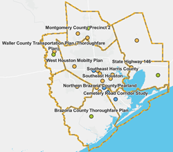
Mobility Plans
Roadmaps for developing or enhancing local transportation networks by making recommendations for transportation improvements in a specific area within the next 0-20 years. Mobility Plans consider the needs of all roadway users and is a collaborative effort between local governments in the area. Mobility Plans typically include project, program, and policy recommendations, and may include recommendations for Thoroughfare Plan updates and additional studies.
Mobility Plans
Buffalo Bayou East Design Concept - In Progress
Pearland Mobility Study (2025)
East End Mobility Study (2012)
East Port Area Subregional Plan (2010)
Fort Bend County Subregional Plan (2013)
Greater West Houston Mobility Plan (2015)
Liberty County Mobility Study (2022)
- Liberty County Mobility Study
- Executive Summary
- Document
- Appendices A Data Collection
- Appendices B Meetings
- Appendices C Public Engagement
- Appendices D Synchro
- Appendices E Recommendations and Implementations
Montgomery County Precinct 2 Mobility Plan (2022)
- Montgomery County Precinct 2 Mobility Plan
- Executive Summary
- Document
- Roadway Inventory Summary
- Appendix A Recommendations
- Appendix B Data Assembly
- Appendix C Roadway Inventory
- Appendix D Issues and Needs
- Appendix E Existing Deficiencies and Challenges
- Appendix F Public Engagement
- Appendix H Universe of Alternatives
- Appendix I Implementation and Funding
Northern Brazoria County/Pearland Subregional Plan (2013)
Old Sixth Ward/TIRZ 13 Phase II Mobility Plan (2024)
SH146 Subregional Plan (2018)
South Montgomery County Precinct 3 Mobility Plan (2015)
Southeast Harris County Subregional Study (2022)
Southeast Houston Mobility Plan (2021)
Waller County Transportation Plan (2019)
Thoroughfare Plans
Long-range plans (0-50+ years) identifying the general location and type of roadway facilities needed to meet projected future growth within an area. Thoroughfare Plans may include recommendations addressing right-of-way (ROW) width, connectivity, and street classifications. A Thoroughfare Plan is not a list of road construction projects but rather a guide to help local governments hold on to existing or potential corridors for a future transportation system.
What is a Thoroughfare Plan?
A Thoroughfare Plan is a long-range plan (50+ years) that identifies the location and type of roadway facilities that are needed to meet projected long-term growth within the area. The Thoroughfare Plan is not a list of construction projects but rather a tool to enable Counties and/or Cities to preserve corridors for transportation system development as the need arises.
Many of the proposed arterial and collector streets identified in the Regional Thoroughfare Plan will likely not be needed or constructed within the next 20 or 30 years. However, one of the purposes of the Regional Thoroughfare Plan is to preserve needed transportation corridors so that as development occurs in the future, Counties and/or Cities will have the ability to develop appropriately sized transportation facilities to serve the needs at that time.
A Thoroughfare Plan is…
- Long range (50+ years)
- Identifies type and general location of future transportation corridors
- Preserves transportation corridors (i.e. right-of-way)
- Guides future development
- Promotes connectivity and design uniformity
- Informs public of future roadway needs
- Requires, through the platting approval process of cities and counties, appropriate dedication of rights-of-way and construction of identified thoroughfares by private land owners
A Thoroughfare Plan is Not…
- List of construction projects
- Commitment by local governments to build specific roads
- Survey, design or engineering study showing the exact alignments
- Ranking or prioritization of roadway improvements
- Set timeframe for when a project should be complete
- Financial plan or funding mechanism
Benefits of a Thoroughfare Plan
The advantage of a regional thoroughfare plan is that it indicates where entities should preserve roadway right-of-way (ROW) so that as development occurs or as traffic increases, the entity has sufficient space to develop appropriate transportation facilities. This planning tool designates a system of major roadways throughout the region intended to provide adequate access and mobility.
The Regional Thoroughfare Plan also supports orderly and anticipated development as private development occurs and minimizes disruption and displacement of people and businesses by providing a long-range, predictable plan.
Things to Consider
Roadway Alignments
A Thoroughfare Plan displays the proposed general alignments for the extensions of existing collector and arterial roadways and planned new roadways. It is important to note that the actual alignments of these roadways will likely vary somewhat from this plan and will be determined through the subdivision development process and the preliminary engineering phase of design.
Slight modifications to facility locations, such as a shift of an alignment several hundred feet one way or another or changes in roadway curvature are warranted and accepted as long as the intent of the Thoroughfare Plan to provide system connectivity and appropriate types of facilities is not compromised.
As development occurs, alignment studies will be needed to determine the exact location of some roadways, keeping in mind the overall purpose and intent of the Thoroughfare Plan and the alignments shown on it.
Functional Classification
An effective transportation system is comprised of a network of roadways, each with its own designation, function and capacity within the overall system. Each street segment contributes to the interconnectivity of the network. Therefore, for a network to operate efficiently, a complete network of roadways designed in a hierarchy from highway to arterial to collector is essential to local street networks.
Each link is intended to function according to its design capacity, in effect distributing traffic from the highest functional classification - highway or expressway - to the lowest design classification. Connectivity is key to providing an efficient, safe, and convenient roadway network for vehicular traffic.
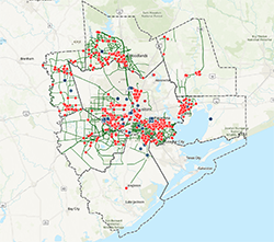
Regional Thoroughfare Plan
H-GAC's Regional Thoroughfare Plan is comprised of existing thoroughfare plans located within the eight-county transportation management area. These thoroughfare plans complement each other so the roadway network performs as a well-coordinated, efficient, and effective roadway system.
Many of the proposed arterial and collector streets identified in the Regional Thoroughfare Plan will likely not be needed or constructed within the next 20 or 30 years. However, one of the purposes of the Regional Thoroughfare Plan is to preserve needed transportation corridors so that as development occurs in the future, Counties and/or Cities will have the ability to develop appropriately sized transportation facilities to serve the needs at that time.
- Regional Thoroughfare Plan (H-GAC-2022-Regional-Thoroughfare-Plan (20000×15000)
Local Thoroughfare Plans (prepared by H-GAC)
Brazoria County Thoroughfare Plan (2020)
Chambers County Thoroughfare Plan (2025)
Galveston County Thoroughfare Plan – Coming soon
Liberty County Thoroughfare Plan – Update underway
Montgomery County Thoroughfare Plan (2016)
Waller County Thoroughfare Plan (2019) – Update coming soon
(Note: This plan is part of the 2019 Waller County Transportation Plan.)
- Executive Summary
- Document (note: the Thoroughfare Plan begins on page 63)
- Map
Other Local Thoroughfare Plans (not prepared by H-GAC)
City of Houston Thoroughfare Plan
Fort Bend County Thoroughfare Plan
- Fort Bend County Public Reference Map – under the Thoroughfare Plan layer
Montgomery County (2021)
Corridor Studies
Studies focusing on a specific corridor that may include alternatives for roadway configurations and alignments, and recommend improvements to make the street safe for everyone and reduce congestion. The study area usually includes a quarter-mile buffer around the corridor.
Access management is a type of corridor study. The goal is to improve safety, mitigate congestion and improve traffic flow by controlling where vehicles may enter and leave the road.
Corridor Studies
Friendswood Parkway Corridor Study (2025)
Pearland FM 518 Corridor Study (from McLean Road to E. Edgewood Drive) (2025)
Cemetery Road Corridor Study (2024)
Washington Avenue Corridor Study (WACS) (2025)
Before and After Access Management Study (2014)
US 90A Access Management Study (2014)
SH 249 Access Management Study (2015)
FM 517/SH 3 Access Management Study (2013)
FM 1092-Stafford Access Management Study (2013)
FM 1092-Missouri City Access Management Study (2012)
FM 1764-Texas City Access Management Study (2012)
SH 105 Access Management Study (2012)
US59/IH69 Southwest Freeway Congestion Mitigation Study (2015)