
On This Page
Summary and Goals
The South Belt Livable Centers Study aims to guide future public and private investment toward creating a more connected, resilient, and opportunity-rich community. Through proactive and inclusive planning, the South Belt area has the potential to evolve into a vibrant Livable Center that supports residents, workers, and visitors alike. The goal of this study is to advance multimodal transportation options, create resilient and high-quality places, economic development, and expand housing choice.
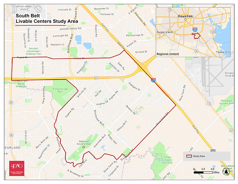
The South Belt Livable Centers study area is located between Fuqua Road and Dixie Farm Road, west of I-45, spanning portions of the City of Houston and unincorporated Harris County, and bordering the cities of Pearland and Friendswood. The study area faces several persistent challenges, including limited transit service— particularly in the western areas—along with insufficient pedestrian and bike infrastructure. Many residents experience barriers to reaching jobs, schools, parks, and essential services.
Following the 2022 redistricting, the South Belt community transitioned from Precinct 1 to Precinct 2 and is now part of Commissioner Adrian Garcia’s Revive2Thrive initiative, which prioritizes community planning for unincorporated areas.
A key objective of the South Belt Livable Centers Study is to develop a community-driven action plan that:
- Improves first/last mile connections
- Enhance transit access and safety
- Advances environmentally sustainable and flood-resilient infrastructure
- Promotes transit-oriented development and equitable access to opportunity
- Conducts inclusive and meaningful public engagement
- Supports balanced, implementable strategies
Study Area Map
Click for a full size version of this map.