
On This Page
Workshop Announcement
The Houston-Galveston Area Council (H-GAC) in partnership with the Texas Commission on Environmental Quality (TCEQ) invites you to attend a free workshop focused on providing homeowners with information on how to maintain their on-site sewage facilities (septic systems). These practices help to implement watershed protection plans in the West Lake Houston Basin. All workshops will be held on Wednesday, July 29th at three locations throughout the basin. RSVP to join us at any of our three in-person meeting locations by clicking on the following links:
The Woodlands
Date and Time
Wednesday, July 29, 2026
10:30 am to 11:30 pm
Location
George and Cynthia Woods Mitchell Library
8125 Ashlane Way
The Woodlands, TX 77382
Conroe
Date and Time
Wednesday, July 29, 2026
2:30 pm to 3:30 pm
Location
Montgomery County Memorial Library System
Central Library
104 Interstate 45 N
Conroe, TX 77301
Spring-Cypress
Date and Time
Wednesday, July 29, 2026
6:30 pm to 7:30 pm
Location
Barbara Bush Branch Library
6817 Cypresswood Dr.
Spring, TX 77379
Project Overview
The Houston-Galveston Area Council and Texas Commission on Environmental Quality are working with stakeholders in the West Lake Houston basin area to implement strategies to protect human health by addressing water quality pollution. This project will make recreation safer, improve the environment, and raise awareness about the connection between waterways and the communities they support.
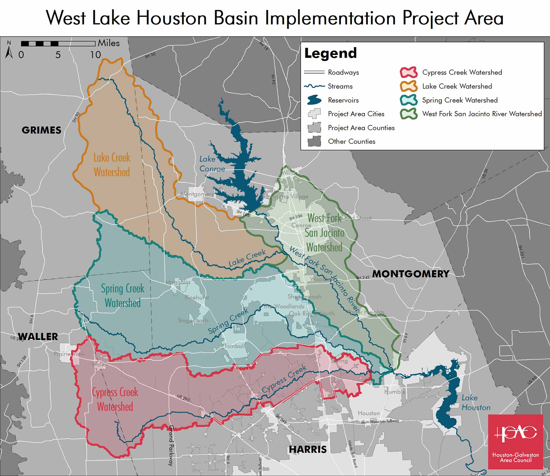
The West Lake Houston basin area is comprised of watersheds for Lake Creek, West Fork San Jacinto River, Spring Creek, and Cypress Creek. The total drainage area covers approximately 1,250 square miles of Harris, Waller, Montgomery, and Grimes counties. Lake Creek, Spring Creek, and Cypress Creek each form a confluence with the West Fork of The San Jacinto River which drains into Lake Houston—an important source of drinking water for the region. Smaller cities such as Cut and Shoot, Magnolia, Oak Ridge North, Panorama Village, Pinehurst, Prairie View, Porter Heights, Shenandoah, Stagecoach, Waller, Willis, and Woodloch intersect or are completely contained within the basin area. Larger cities that intersect or are contained within the basin area include Conroe, Houston, Humble, Spring, The Woodlands Township, and Tomball.
Assessments of surface water quality in the West Lake Houston basin indicate elevated levels of fecal indicator bacteria, depressed dissolved oxygen, high concentrations of nutrients, and occasional issues with poor quality fish and macrobenthic communities and habitat. Other issues identified by stakeholders include sediment loading (from development), changes in flow velocity and volume, illegal dumping, trash, and bank erosion.
Watershed Protection Plans (WPPs) have been developed for the watersheds of Lake Creek, West Fork San Jacinto River, Spring Creek, and Cypress Creek to address these issues. The goal of the West Lake Houston Implementation Project is to actively implement elements of these WPPs to address pollutant sources through coordinated voluntary measures. These activities will move the component watersheds toward achieving and maintaining compliance with applicable water quality standards and address other stakeholder concerns.
Funding for this implementation project is provided through a federal Clean Water Act §319(h) grant to the Houston-Galveston Area Council, administered by the Texas Commission on Environmental Quality from the United States Environmental Protection Agency.
Documents
( 3)
Meetings and Workshops
The Houston-Galveston Area Council (H-GAC) in partnership with the Texas Commission on Environmental Quality (TCEQ) invites you to attend a free workshop focused on providing homeowners with information on how to maintain their on-site sewage facilities (septic systems). These practices help to implement watershed protection plans in the West Lake Houston Basin. All workshops will be held on Wednesday, July 29th at three locations throughout the basin. RSVP to join us at any of our three in-person meeting locations by clicking on the following links:
The Woodlands
Date and Time
Wednesday, July 29, 2026
10:30 am to 11:30 pm
Location
George and Cynthia Woods Mitchell Library
8125 Ashlane Way
The Woodlands, TX 77382
Conroe
Date and Time
Wednesday, July 29, 2026
2:30 pm to 3:30 pm
Location
Montgomery County Memorial Library System
Central Library
104 Interstate 45 N
Conroe, TX 77301
Spring-Cypress
Date and Time
Wednesday, July 29, 2026
6:30 pm to 7:30 pm
Location
Barbara Bush Branch Library
6817 Cypresswood Dr.
Spring, TX 77379
Join our mailing list for future updates.
Partner Agency Links
![]()
![]()