
On This Page
Regional Land Use Information System (Regional Growth Forecast)
View and query our land use data, review our land use map and submit data queries for the H-GAC region with our Regional Land Use Information System web based mapping application.
Current and Future Land Use, and Regional Growth Forecast data displayed in the Regional Land Use Information System application are available for download in ESRI file geodatabase format (requires version ArcGIS 10.0 or higher). Please use our online Data Request Form. Upon successful completion of the online form, which includes acceptance of our terms and conditions, you will receive an e-mail confirmation with a link directing you to the download website.
Land Cover Change Application
The Land Cover Change Application offers access to the Houston-Galveston Area Council’s (H-GAC) Land Use Land Cover (LULC) data. Leveraging advanced satellite imagery processing and data analysis techniques, it delivers detailed analysis, including change detection. The application's use of cutting-edge methods ensures accurate interpretation, providing profound insights into the region's diverse land cover through interactive maps and charts.
H-GAC Land Cover Data Sets
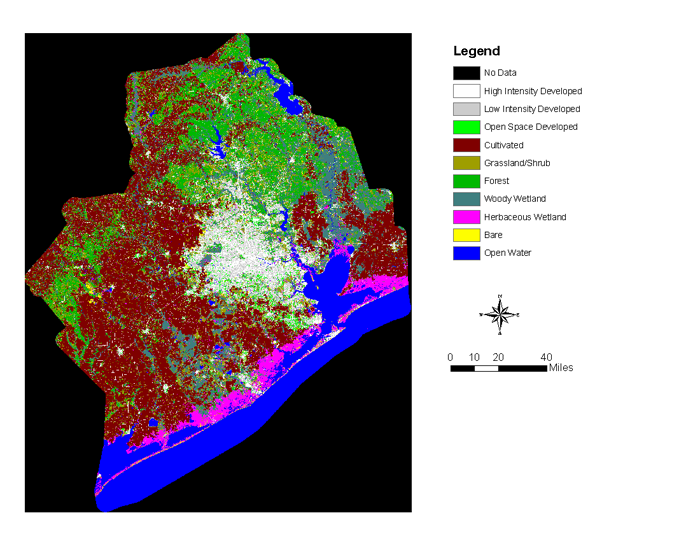
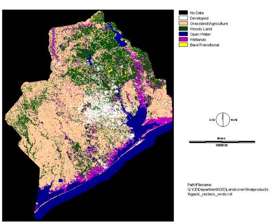
2022 15 Class Land Cover Data Set
These land cover datasets were produced by the Data Analytics and Research (DAR) department at the Houston-Galveston Area Council (H-GAC) for the purpose of developing land cover data product with a level of accuracy suitable for planning and research applications at the regional scale.
The dataset was developed based on Landsat 8 Operational Land Imager (OLI) and the Thermal Infrared Sensor (TIRS) scenes of 30m resolution acquired from the USGS. Twelve scenes with 0-5% cloud cover were used to cover the entire area for diverse seasonal coverage. Using pixel classification with Deep Learning (DL) techniques available in ESRI ArcGIS Pro product with Image Analyst extension, the imageries were classified into 15 major land cover classes. Classification classes were determined based on NLCD land cover classification schemes. The output cell size is in 30 meter (98.425 Feet) resolution.
2022 15 Class / Metadata / Technical Document / Coverage Map
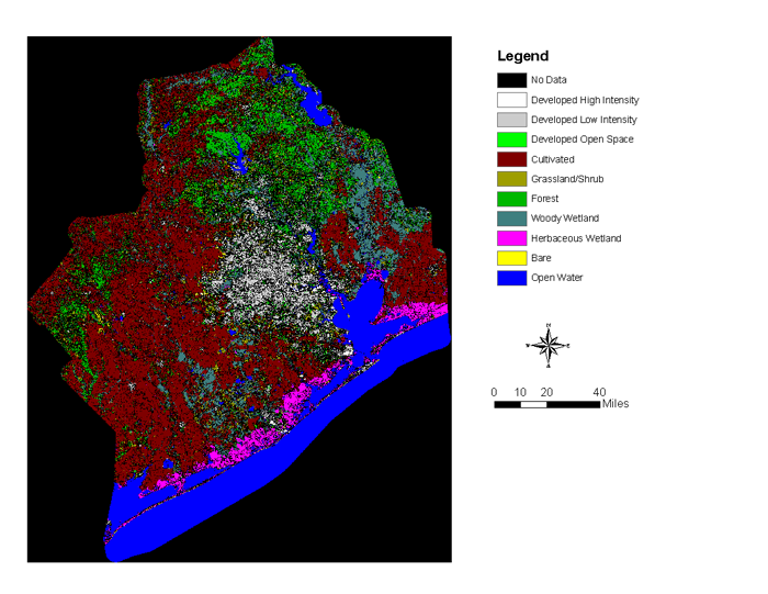
2020 15 Class Land Cover Data Set
These land cover datasets were produced by the Data Analytics and Research (DAR) department at the H-GAC for the purpose of developing land cover data product with a level of accuracy suitable for planning and research applications at the regional scale.
The dataset was developed based on LandSat 8 Operational Land Imager (OLI) and the Thermal Infrared Sensor (TIRS) scenes of 30m resolution acquired from the USGS. Four scenes with 0-5% cloud cover were used to cover the entire area. Using pixel classification with Deep Learning (DL) techniques available in ESRI ArcGIS Pro product with Image Analyst extension, the imageries were classified into 15 major land cover classes. Classification classes were determined based on NLCD land cover classification schemes. The output cell size is in 30 meter (98.425 Feet) resolution.
2020 15 Class / Metadata / Technical Document / Coverage Map
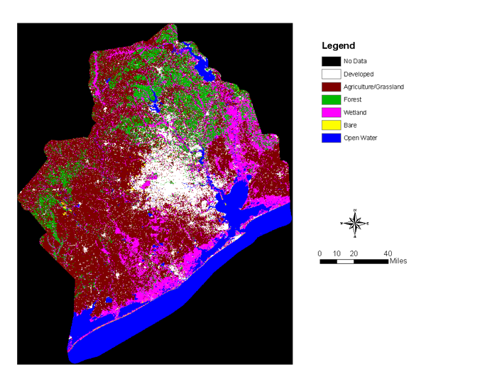
2018 10 Class Land Cover Data Set
These land cover datasets were produced the Data Analytics and Research (DAR) department at the H-GAC for the purpose of developing land cover data product with a level of accuracy suitable for planning and research applications at the regional scale.
The dataset was developed based on LandSat 8 Operational Land Imager (OLI) and the Thermal Infrared Sensor (TIRS) scenes of 30m resolution acquired from the USGS. Four scenes with 0-5% cloud cover were used to cover the entire area. Using supervised and unsupervised classification techniques in ENVI remote sensing package and ArcGIS Image Classification Tools, the imageries were classified into 10 major land cover classes. Classification classes were determined based on the NOAA and NLCD land cover classification schemes. The output cell size is in 30m resolution.
2018 10 Class / Metadata / Technical Document / Coverage Map
2015 10 Class Land Cover Data Set
2015 10 Class / Metadata / Technical Document / Coverage Map
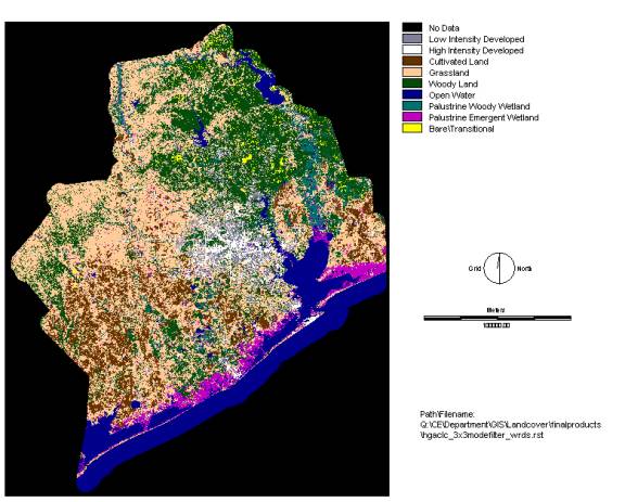
2008 Land Cover Data Set
H-GAC unveiled the 2008 land cover data set which maps the 15 counties that encompass the Clean Rivers Program's (CRP) assessment basins.
The 2008 land cover data set updates the 2002 land cover map and is available in three formats: an original 10 category classification and two reprocessed classifications which slightly modify the original map. The 10 category classification used in this land cover delineation follows the hierarchical classification scheme utilized by the National Land Cover Data (NLCD).
Due to accuracy limitations the land cover data is not to be used for regulatory, jurisdictional or local planning decision making without thorough field verification.
2002 Land Cover Data Set
H-GAC's 2002 Land Cover data set classifies the region's landscape into nine land cover categories.
The Land Cover data is available in three formats: An original nine category classification, and two reprocessed classifications based on the original classification.
Due to accuracy limitations of the classification, this data is not to be used for regulatory or jurisdictional decision making without rigorous or intensive field verification efforts.
Use the links below to review a sample image of each product or to download. All datasets are in UTM 15 Projection, Units Meters, Datum NAD83.

Other Land Cover Data Sets
NLCD Land Cover Data
1992 19 Class / Metadata
1992 19 Class Corrected / Metadata
2001 15 Class / Metadata
2001 15 Class (Corrected) / Metadata
2006 15 Class / Metadata
NOAA Land Cover Data
1996 22 Class / Metadata
2001 22 Class / Metadata
2005 22 Class / Metadata
2011 15 Class / Metadata
2011 22 Class / Metadata
Land Cover Change Data Sets
More Information
H-GAC Clean Rivers Program Assessment Basins Map
H-GAC Clean Rivers Program Assessment Basins Map
Methodology for Developing Land Cover Data
Disclaimer
These products are for informational purposes and may not have been prepared for or be suitable for legal, engineering, or surveying purposes. They do not represent an on-the-ground survey and represents only the approximate relative location of property boundaries. Mapping may not reflect on-the-ground conditions. The Houston-Galveston Area Council makes no further claims as to the accuracy or reliability of the data, and neither assumes, nor will accept liability for their use. All mapping products on this website are the copyright of H-GAC and should not be sold, reproduced, or published without the written consent of H-GAC.