On This Page
Best Management Practices
This page contains information regarding the types of Best Management Practices ( BMPs) that are best suited to certain areas along the transect from urban to rural land use. Information will be added as it becomes available.
Nonpoint souce pollution comes from variety of souces and land uses. Depending on the source of the contaminant, the pollutants can vary widely and so do the sources of remediation of the problem.
Best Management Practices (BMPs) for a variety of land uses have been identified along the rural to urban land use transect. BMPs are the guildelines and practices that are designed to reduce pollution from stormwater runoff. The San Bernard River watershed is a very diverse watershed with many different land uses. Land uses in the northern portion of the watershed are primarily rural and natural areas where grazing and agricultural production take place.
Towards the Southern end of the watershed, land uses are more suburban and residential with more impervious surfaces. The source of the water quality issues in the San Bernard Watershed are caused by nonpoint source pollution, and this can be reduced by helping to prevent pollution in the first place and by treating affected waters. Below are several categories of BMPs and examples the type of measures that could be implemented.
Water Smart Landscaping
- Use of native and noninvasive adapted plants that require less fertilizer and little to no pesticides
- Environmentally friendly landscapes
- Municipalities converting public spaces to a watersmart standard
Good Housekeeping
- Education on proper use, storage and management of household materials
- Household hazardous waste collection days
- Encourage use of alternative, nontoxic products
Construction Site Erosion Control
- Use of silt fences around the perimeter of construction sites
- Use of compost as a filter berm to contain sediments
Low Impact Development
- Vegetated swales
- Rain gardens
- Green roofs
- Porous pavements
- Retention ponds
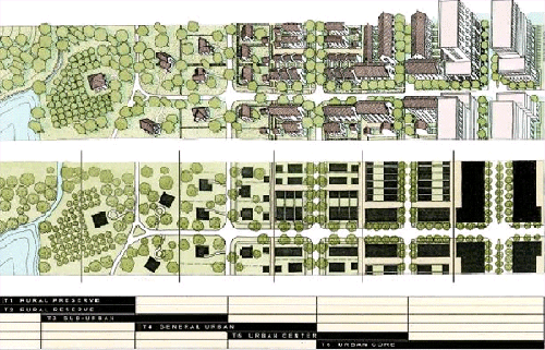
Types of Nonpoint Source Pollution and Land Use Relationships with the Transect Zones
Nonpoint source pollution is the result of water flowing over the land and collecting all of the sources of contamination and ending up in the waterways. Since it is the combination of all sources, it cannot be easily identified and linked to one land use. Each of the development zones along the transect are associated with particular uses and each of these uses is associated with typical pollutants.
| Development Zone | Dominant Land Uses | Typical Pollutant Examples |
|---|---|---|
| Natural | recreational | bacteria (natural) |
| Rural | agricultural | nutrients, sediment, pesticides, bacteria (food animal) |
| Sub-Urban | residential | nutrients, bacteria (pet waste) |
| General Urban | mix of residential, commerical, industrial | oil and grease, toxics, bacteria (effluent), metals |
| Urban Center | dense residential, dense commercial, industrial | oil and grease, toxics, bacteria (effluent), metals |
| Urban Core | densest commercial and residential | oil and grease, toxics, bacteria (effluent) |
Selected Stormwater Treatment Practices by Type of Development
Below are selected stormwater treatment practices organized by type of development. Most appropriate BMPs for each type of development are highlighted in darker green, and ligher green indicates appropriate, but less effective BMPs for each type of development.
| RURAL | URBAN | ||||
|---|---|---|---|---|---|
| Natural Reserve | Natural Preserve | Suburban | Neighborhood Center | Urban Center | Urban Core |
| Watersmart Landscaping | |||||
| Good Housekeeping | |||||
| Porous Pavement | |||||
| Bioretention/Swales | |||||
| Conservation Easements | |||||
| Soil Conservation | |||||
| Low Level Development | |||||
| Repair/Replace Septic Systems | |||||
| Stormwater Ordinances | |||||
| Educational Outreach | |||||
| Detention Basins | |||||
| Tree Boxes/Sand Filters | |||||
| Green Roofs | |||||
| Water Quality Inlet Separators | |||||
Transect Zoning Categories
Source: “Choices For Growth” TAMU-SG-05-701, P. 13, as presented online.