
On This Page
As a forum for local government discussion, problem-solving, and cooperation, the Houston-Galveston Area Council conducts extensive research to inform its planning programs and assist local policymakers in decision-making.
H-GAC makes much of its data and research projects available to the public through various easily accessible online research and mapping tools: interactive web mapping applications and reports.
Socioeconomic Modeling and Analysis
H-GAC conducts socioeconomic modeling and analysis to develop a long-range forecast of population, employment, and land use for the region. The forecast includes macro and micro modeling – The macro modeling assesses regional demographic and economic trends and predicts future population and employment totals for the region. The micro modeling predicts new residential and non-residential buildings on specific parcels to accommodate future households and jobs.
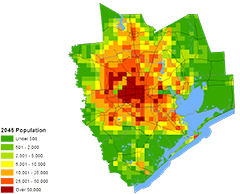
The forecast, in tandem with other agency research and modeling programs, supports H-GAC’s major planning efforts and is widely used by other public agencies and private businesses throughout the region.
COVID-19 Impacts on Land Use and Mobility
H-GAC’s Socioeconomic Modeling team released a report analyzing the impacts of COVID-19 on land use and mobility.
Transportation Planning and the Metropolitan Planning Organization
H-GAC is the Metropolitan Planning Organization responsible for transportation planning in Harris and its seven contiguous counties. The agency conducts qualitative and quantitative research to assess and predict travel behaviors to identify short- and long-range transportation investment priorities. H-GAC conducts household travel surveys to understand travel purpose, choice of travel mode, and route; and regularly monitors and analyzes data on traffic volumes, congestion, and crashes. This data is a key input into H-GAC’s regional Travel Demand model that predicts the future travel patterns and mode choices expected from expected growth in the region.
Specialized transportation modeling projects under development include: a Freight-Cargo Model and a Tour-Based Truck Model to predict the amount of cargo and volume of trucks expected on the region’s roadways; tools for estimating the cost-benefit of proposed transportation investments; and Eco-Logical, an online mapping tool to assess potential environmental impacts of transportation projects.
Equity in Transportation Planning
H-GAC conducts research and analysis to assess the outcomes of transportation policy decisions on disadvantaged populations. Environmental Justice: H-GAC’s Strategy for the Fair Treatment and Meaningful Involvement of All People (2017) summarizes this research, assessing environmental justice in the regional transportation system, including how it links all people to their daily destinations and broader opportunities. Key measures evaluated include the distribution of transportation investments, accessibility to public amenities and vital services, the state of transportation safety, and public involvement.
Air Quality
Regional air quality analysis is the key in determining the conformity of transportation plans, programs, and projects with federal Clean Air Act standards. H-GAC’s air quality modeling program involves a broad range of technical processes and research. Its analysis uses a regional inventory of air emissions and projects the impact of major transportation investments, as well as emissions reduction programs, such as Commute Solutions, Air Check Texas, and other voluntary strategies.
Water Quality
H-GAC conducts statistical analyses on ambient surface water quality data from more than 400 sampling locations throughout the H-GAC region. These data and analyses are used to determine the health of area water bodies and verify whether they are meeting water quality standards.

H-GAC uses water quality models to predict the sources and amount of pollution entering the region’s waterways from stormwater runoff. This information is used to develop strategic pollution reduction plans for targeted watersheds.
Workforce Analysis
H-GAC analyzes labor market conditions, economic trends, and the regulatory environment to help businesses address their workforce challenges. These analyses include employment statistics, unemployment rates, growth occupations, industry special reports, and other workforce-related data.
Geographic Information System Data and Analysis
H-GAC facilitates the sharing of geographic data and information resources for the H-GAC region. This includes managing current and historical aerial imagery acquisition, providing a platform and workflow for sharing Geographic Information System (GIS) data and analysis via online services, and supporting the GIS needs of H-GAC users and member agencies.
Emergency Communications Data
H-GAC staffs the Gulf Coast Regional 9-1-1 Emergency Communications District, which provides technical support for eight counties (Brazoria, Chambers, Colorado, Liberty, Matagorda, Walker, Waller, and Wharton), 23 public safety answering points, 224 emergency service providers, and numerous telephone companies, including network monitoring, database management, and other technical services.